

Entrance sign and information kiosk.
Entrance sign and information kiosk.
Situated in the southwest corner of Indian River County, Florida between State Road 60 and the Florida Turnpike, approximately 20 miles west of Vero Beach.
From I-95 (exit 68), take SR 60 west for about 23 miles. Entrance to Fort Drum Marsh will be on your left.
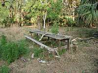
Don't worry... this is not one of the campsites. This one was abandon a long time ago. It even has a tree growing through the middle of the table.
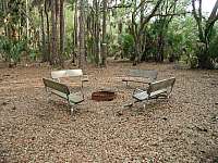
Tent camping is permitted at designated campsites on a first come, first served basis. Fort Drum Marsh has 6 campsites: 3 at Horseshoe Lake, 2 on Hog Island and 1 group camp site near the end of the entrance road. None of the campsites have potable water. Port-o-lets are located at the check station and the group camp site. Each campsite has iron grills to cook on and some, like the one in the picture, have benches. A word of caution: the campsites at Horseshoe Lake are covered with Poison Ivy.
Fort Drum Marsh has about 5 miles of hiking trails. The trailhead is located at the end of the entrance road near the pavilion. Plenty of parking is available.

For a short 1/2 mile loop hike, follow the white blazes around Horseshoe Lake. There's a very nice bridge that will take you over to one of the islands in the middle of the lake.


To access the rest of the trails, follow the entrance road (blazed blue) beyond the gate for about a 1/2 mile. This will take you to a very nice, long boardwalk (it's worth seeing, believe me!) that cuts through hardwood swamps to get to Hog Island. Once your on Hog Island, you're faced with a maze of trails. It's easy to get all turned around and going in circles, if you're not careful. There are no trail signs, so it might be advisable to bring a map or drop some bread crumbs along the way. The trails are laid out into two loops (blazed orange) with two interconnecting trails (blazed white). There's also two side trails (blazed blue) that lead you to campsites. The only way out is the way you came in (unless you take one of the service roads).
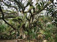
Old oak trees covered with Spanish Moss are a common sight at Hog Island.
The Florida Fish and Wildlife Conservation Commission manages hunting at Fort Drum. For up-to-date information on regulations and current hunting schedules, please go to MyFWC.com.

Check station located next to Lake Cara.
Hunting Schedule 2012 - 2013 Wild Hog - Still Oct. 5 - 7, 12 - 14, 19 - 21 Spec. Op. - Deer Oct. 27 - Nov. 2 Small Game Dec. 8 - 23 Spec. Op. - Turkey Mar. 16 - 22, 30 - Apr. 5, 13 - 19
File Formats Downloads Garmin MapSource trails.mps TopoGraphix ExpertGPS trails.gpx Google Earth trails.kmz


American Bluehearts, Rattle Box and Hairy Indigo

Last updated on 13-Sep-2012


