The Tosohatchee Railway

Believe it or not there was actually a railroad spur that came into Tosohatchee many years ago. I'm not sure how old it is, but I have seen the tracks on several aerial maps dating as far back as 1939.  It was actually on some of Orange County General Highway maps during the 1950s.

Even today you can still find signs of the old railroad. All you have to do is walk down the white blazed trail along Fish Hole Road. There you can see old cross ties and a 18 foot rusty rail lying along side the trail.

Rail from an Old Railroad Roadroad Tie

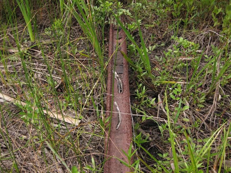
There's even an old pair of friction bearing journal boxes discarded in the woods nearby. They normally sit on the ends of the train car axles and are typically filled with oil soaked wool waste to keep the bearings lubricated.1

Wheel Bearing Box in 2010 Wheel Bearing Box in 2010 Wheel Bearing Box Lettering in 2010

The railroad was probably put in during the 1910s or 1920s to harvest the huge cypress trees that were in the Jim Creek and Tosohatchee Creek area.  Back then the land was primarily owned and leased by big timber companies like Rupp-Holland Logging Company and Brooks-Scanlon Corp. Typically these companies would run narrow gauge tracks out to the harvest site from a nearby sawmill, then use steam locomotives to haul the timber out.

So where was the sawmill? That's a good question. If you were to follow the old Tosohatchee railroad spur heading west,  it would eventually tie into the Florida East Coast Railroad Kissimmee Valley Line about 2 miles south of Bithlo. According  to William Blackman's book, the History of Orange County, Florida, there was a sawmill in that area operated by Mr. John H. Tucker for the Rutherford Lumber Company. The book also refers to a tramway that was built by the Osceola Lumber Company to take out cypress trees along Long Branch. The Tosohatchee railroad spur just so happens to go right by Long Branch. Makes you wonder if they are the same two railroads.  There was also a sawmill in the heart of Bithlo called the Brown and McIntosh mill. So the timber from Tosohatchee could have gone to a number of places including all the way down south to Holopaw where there was another large sawmill..

By using some GIS software, I was able to extract the following locations of where the railroad tracks crossed roads, trails, creeks and other features from the old aerial maps. 

  1. Railway ends near Fish Hole Road at N28º 28.455 W80º 57.509.
  2. Heads north along a white blazed trail for about a mile. There's an old rusty rail (about 18 ft long) lying in the bushes at N28º 29.056 W80º 57.590.
  3. Crosses the old road to Beehead Ranch (also known as the Bear Head Gap Trail) at N28º 29.490 W80º 57.629.
  4. Leaves the white blazed trail at N28º 29.551 W80º 57.656 and turns northwest.
  5. Crosses the corner of some Deseret Ranch  property before coming back out onto Beehead Road at N28º 29.893 W80º 58.258.
  6. Follows Beehead Road west until it crosses St. Nicholas Road at N28º 29.922 W80º 58.762.
  7. Turns northwest and crosses a white blazed trail at N28º 30.119 W80º 59.614.
  8. Crosses Powerline Road at N28º 30.219 W80º 59.696.
  9. Crosses Tosohatchee Creek at N28º 30.288 W80º 59.761.
  10. Enters Deseret Ranch property and starts heading more west-northwest.
  11. Crosses Taylor Creek Road at  N28º 30.440 W81º 00.237. Area is very overgrown.
  12. Intersect with another old railroad grade at N28º 30.576 W81º 00.882 but does not tie into it.
  13. Crosses SR 520 at N28º 31.599 W81º 04.365.
  14. Finally it merges in the old Florida East Coast Railroad Kissimmee Valley Extension  (present day CR 13) near Bitho at N28º 31.806 W81º 05.843.

Maps

Railroad Connection with the FEC in 1947

1947 Aerial Map of Railroad

1955 Railroad Map

Railroad Tracks

GPS Data

File Formats Downloads
TopoGraphix ExpertGPS railroad.gpx
Google Earth railroad.kmz

Updates

2009-07-20: So far the only thing I have found near the Tosohatchee Creek crossing is an old bridge timber (see photo below). It had several large spikes driven into it. Surprisingly the pole was still ridged and could probably hold someone's weight while crossing the creek. It worked for Katie Dog. :-)

Old Bridge Timber in 2009

Foot Notes

  1. Discovered by Doug Sphar while doing trail maintenance.

Back

Previous

Next

Last updated on 5-Sep-2009 at 12:49 P.M.