Three Lakes Wildlife Management Area
The Three Lakes Wildlife Management Area consists
of 63,487 acres of mostly dry prairie
interspersed with
cypress swamps, freshwater marshes, pineland and scrub. The
property is situated in the southern half of Osceola County, west of US
Hwy 441 and north of SR 60, near the town of Kenansville,
Florida. Three lakes (Kissimmee, Jackson and Marian) share
its
boarders, hence the name, Three Lakes. Recreational
activities
include hiking, camping, bike riding, horseback riding, wildlife
viewing, paddling, fishing and seasonal hunting.


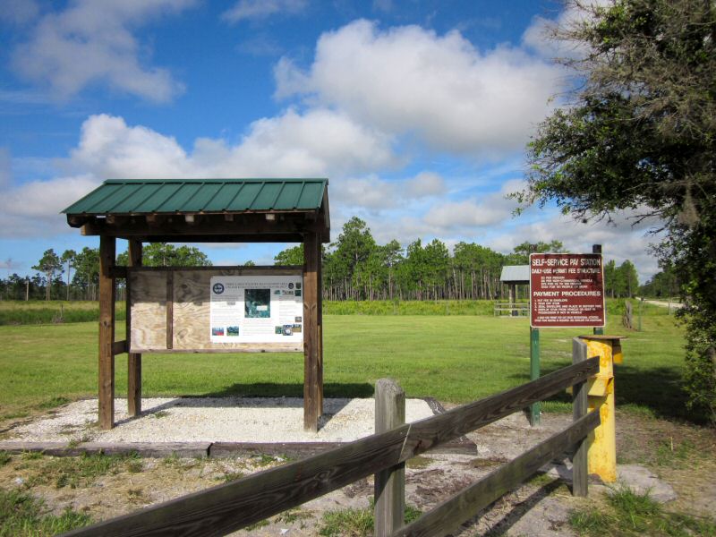
Hwy 441 Entrance and
Information
Kiosk
Directions
To US
Hwy 441 / Williams Road Entrance:
From I-95 exit 180, take US Hwy 192 west for about 23.5
miles.
Turn left on US Hwy 441 and go south for another 13.7 miles. Turn right
onto Williams Road. GPS Coordinates: N27°
57.699 W81° 00.258.
To Canoe
Creek Road Entrance:
From
I-95 exit 180, take US Hwy 192 west for about 23.5
miles.
Turn left on US Hwy 441 and go south for another 19.8 miles. Turn right
onto South Canoe Creek Road (CR 523). Entrance will be on
your left about 11.5
miles (2 miles past the entrance to Priarie Lakes Unit). GPS
Coordinates: N27°
57.131 W81° 08.417.
To SR
60 Hwy Entrance:
From I-95 ext 147, take SR 60 west for about 40 miles.
Entrance will be on your right. GPS Coordinates: N27°
46.717 W81° 07.584.
Entrance Fees
Self-pay (cash or personal check) at the entrance kiosk: $3
per person, $6 per non-commercial vehicle. Hunters and thru-hikers are
exempt.
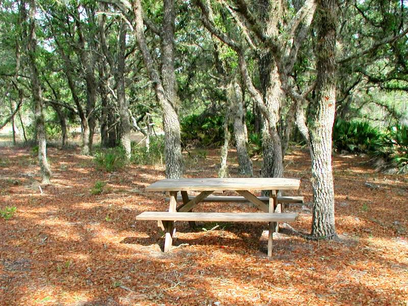
Camping
Three Lakes has two campsite along the Florida National
Scenic Trail. One is
located in
Godwin Hammock about 4 miles north of State Road 60 and the other is
about half way between the Florida Turnpike underpass and US Hwy 441.
The
campsites are available for through hikers only. There are no
Porto-lets, fire rings or
potable
water sources at these campsites. Make sure you bring everything you
need
since
there are no supply stores nearby.


Three Lakes
Campsite and Sign-in Box

Godwin
Hammock Campsite
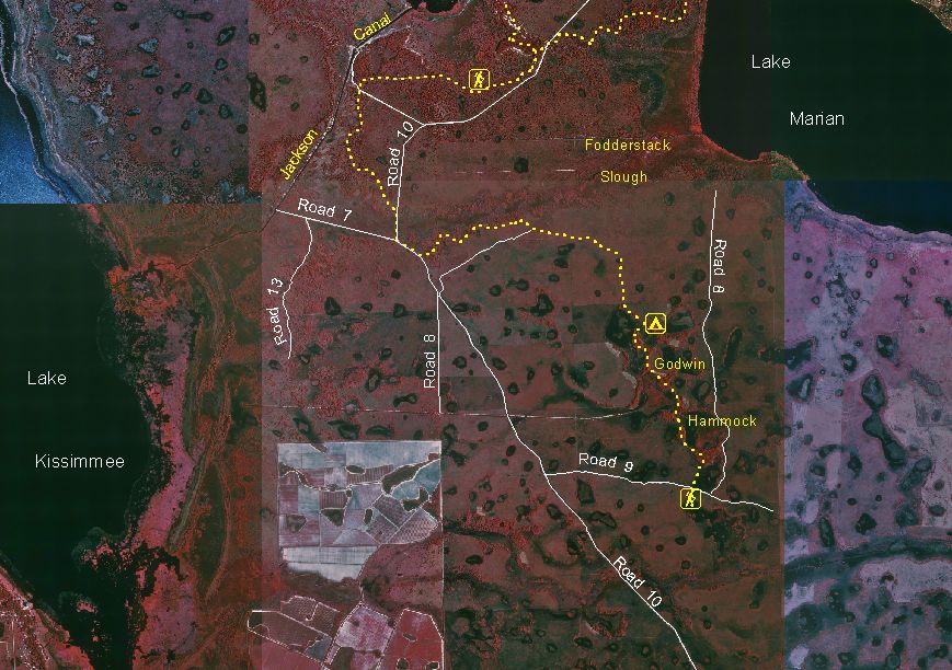
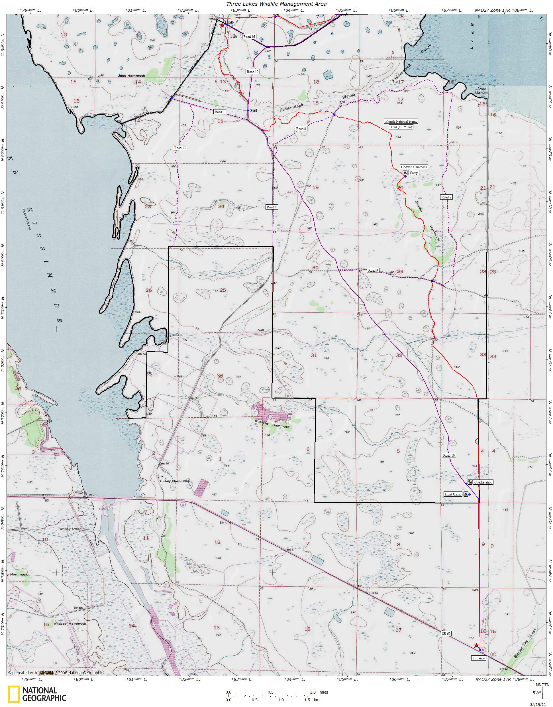
Hiking
Three Lakes consists of over 16 miles of hiking trails
divided into two sections: north and south. The northern
section begins about 2.5 miles north of the park entrance on US Hwy 441
(near the tall radio tower) and passes underneath the Florida Turnpike
before ending at the Prairie Lakes entrance on Canoe Creek Road. The
southern section starts about 5 miles west of the Kissimmee River
bridge on State Road 60 and meanders north and west until it reaches at
the southern border of Prairie Lakes near the Jackson Canal. Each
sections is about 9 to 10 miles long. None of the sections have loops
or designated trailheads since they are primarily used by thru hikers.

Dry Prairie
near Godwin Hammock
If you're a day hiker, the easiest way to get to the trail
is to follow entrance road off of Hwy 441 until you reach the
Florida Turnpike
underpass. There you should see the familiar orange trail
blazes.

Florida
Turnpike Underpass - Williams Tunnel
Old trail registration box near Canoe Creek Road. Use to be a
haven for scorpions.


Trail
Registration Box and Occupant
Hunting
The Florida Fish and Wildlife Conservation Commission
manages hunting at Three Lakes WMA. For up-to-date information on regulations and
current hunting schedules, please go to MyFWC.com.


Hwy 441 and Canoe
Creek Check Stations
| Hunting Schedule 2013 - 2014 |
| Archery |
Sep. 14 - Oct. 13 |
| Muzzle Gun |
Oct. 19 - 21 |
| General Gun - M.I. | Oct. 25 - 27 |
| General Gun | Nov. 2 - Dec. 29 |
| General Gun - Dog | Dec. 5- 8, Dec. 26 - 29 |
| Small Game |
Dec. 30 - Mar. 2 |
| Spring Turkey |
Mar. 8 - 9, Mar. 15 - Apr. 20 |
Maps
- Color infrared aerial maps of the northern
and southern areas of
Three Lakes. Shows hiking
trails, camp sites and roads.


Aerial Maps -
North and South Sections
- Topo maps of the
northern and southern sections of Three Lakes.
Includes trails, campsites and other points of interest.

Topo Map - North
Section

Topo Map - South
Section
GPS Data
Flowers
Local Weather

Trail Conditions
- 2011-07-17: A prescribed burn has obscurred some
of the
blazes north of Canoe Creek Road. Godwin Hammock campsite was also
partially damaged by a fire. One of the benches and the camp sign were
burnt. Well pump is working at Dry Pond campsite. Just needed to be
primed.
- See Old Trail
Notes
Additional Information
Last
updated on 18-Nov-2013